 |
| Mid-ocean, Anna, takes the swell on a dead-down run. |
‘Logic doesn't really have much to do with the
salt-water universe.’
-Bernard Moitessier
THE PLAN WAS TO LAY A
COURSE OF 180 DEGREES TRUE, more
or less, for 31 days and 3,100 nm; this, we figured, would take us directly
from Galapagos to Patagonia, bypassing Easter Island 600 nm to the east. Anna was half way to Easter Island, the
westernmost outpost of Chile, before we realized that the plan we had envisioned
had nothing whatsoever to do with the reality of the moment. Because after 40
days and nights at sea, and 3,401 nm later, we had arrived at Hiva Oa, in
French Polynesia - bearing 270 degrees true; over 5,000 miles away, as the
great albatross flies, from where we had determined we would go, 40 days
earlier.
‘The best laid plans of mice and men oft go astray’.
What had
happened? How did we manage to stray so far away? The South Pacific high had happened; it had been
uncooperative, stubborn, out of character, pesky, but more important, out of
place according to the historical data we were looking at. In order for Anna to make progress in a southerly
direction (after departing the Galapagos) the wind direction needed to favor
the SE quadrant (i.e., east to east-southeast to southeast). And that is what
normally happens in the month of December, off the west coast of South America,
where we began our passage to southern Chile. But this year was an anomaly.
True, it was an El Nino year, and a
strong El Nino event can have a significant
impact on wind direction, strength, and currents, but we don't believe that El Nino was responsible for the shift in
wind direction over the SE Pacific Ocean, as it was questionable according to
NOAA, as to whether or not El Nino
had even developed yet (it was still early December 2014 and the prognosis was
leaning toward a weak to neutral southern oscillation). We believe that the anomaly
was simply a glitch, a snafu which had occurred, coincidentally, at the time
that we were en route, near 11 degrees south latitude and 100 degrees west
longitude.
Technically, a
persistent, strong high pressure system was centered over 30S/110W and this had
the effect of shifting the wind, in our general ocean neighborhood, toward the
SSE, essentially heading us to the southwest and well away from our intended
course. In fact, we had migrated far enough away from our intended course to
land us at either Pitcairn Island or the Gambiers, in southeastern Polynesia, thousands
of miles out of our way. What to do?
 |
| Anna en route to French Polynesia. |
We had been
beating hard to weather for ten straight days, shortly after departing
Galapagos. The SE Trade winds were reinforced, and averaged over 25 knots just
off our port bow. The seas were confused by a cross swell in addition to the short-period
wind waves we were experiencing and their height was in the neighborhood of 3-4
meters on average. Anna happens to go
well to weather, but we were only 1,000 nm into a 3,000 nm to 4,000 nm passage,
and the forecasted grib files promised conditions to deteriorate with higher
strength winds, and bigger seas, both from an unfavorable direction for at
least the next week. We were moving well, but we were not moving in the correct
direction, not unless we were agreeable to reaching Patagonia after a 6,000 nm
ride, out just west of Gambier and then doubling back and riding the 40th
parallel back to southern Chile - a tight beat to weather for the first third
of the passage, then some downwind work in unstable air near the edge of the
cyclone zone, followed a thousand miles later by erratic wind and waves, which
might arise from any quarter and at any time - sprinkled with short but intense
squalls, for the last third of the ride and confused seas to match.
Anna was taking a beating, and so were we, but she's tough and could take it. We on the other hand thought the time had probably come to take a right turn and continue on, downwind for a while. Our heads were spinning, no kidding, and calming life down a bit sounded like just the ticket. Ease the sheets. Re-group. We were at a crossroads so to speak, at the intersection of no and where, at least 2,500 nm from anywhere that we could actually land, drop the hook, take a walk, and sort things out. We had a new decision to make and logic told us that our new destination would be
 |
| Overview of Anna's route to French Polynesia. |
 |
| Under the aluminum dodger in a rain squall. |
It is said that
stainless steel is great, until it isn't...that is, until it suddenly fails,
catastrophically. It was puzzling, if not shocking, how we could have lost this
critical piece of gear, which essentially acted as an ocean-going mechanical
autopilot that would self-steer the boat according to the direction of the wind
(as opposed to a compass course). The reason we have a mechanical self-steering
device is to eliminate the possibility of an electrical failure, in the circuit
boards of an electronic autopilot (something which often occurs at just the
wrong time), from interrupting our ability to steer automatically - it is the
same logic that a ship’s navigator might use to insure that if there is an
electrical failure, the ship's paper charts can be used to complete the journey.
A serious
mechanical failure of a stainless steel wind vane isn't a common occurrence. We
have used our Monitor self-steering device for fifteen years and made multiple
long-distance ocean crossings of the Pacific without incident. However, it should
have been no surprise to us that stainless could in fact fail, and it should go
without saying that if it does fail, it will occur at mid-ocean. Stainless,
even 316-grade steel, will corrode after prolonged exposure in the harshest
environment on earth, the ocean. Hidden crevice corrosion had apparently occurred
in the exterior portion of the stainless tube, which runs through the Monitor's
water paddle (rudder). It's very hard to detect this type of crevice corrosion
and actually do something about it in advance of its failure. It is for this
same reason that insurance companies require stainless rigging to be replaced
at least every ten years when writing an insurance policy for a yacht that is
going to cross an ocean. Failure of the standing rigging is much more serious
than losing the use of a self-steering device. Nonetheless, the loss of a
self-steering device, mid-ocean, is no picnic.
The rudder of an
older Monitor with a lot of years of exposure to the elements – such as our
circa 1987 model, which was constructed with 304-grade stainless steel can
simply shear off and vanish into the abyss if a hidden hairline crack develops
over time. And even though 316-grade stainless is less corrosive, and used in
more recent versions of Monitor wind vanes, we think that close inspection of
the lower parts of the device that are in close proximity to - or actually
submerged - in the ocean, merit careful inspection for signs of crevice
corrosion before the passage begins. Try loosening the lower bolts on the brackets
that secure the Monitor’s frame to the hull. If the head of the bolt shears
off, or if the bolt is corroded and won’t come out, it’s time to replace the
hardware and very carefully inspect the hinge assembly and rudder tube for
signs of pending trouble. Jury-rigging a replacement rudder may be difficult to
impossible, especially in seas of any size while underway.
In our case we
were left with only two options: either hand steer Anna, 24/7, for the next thousand miles (i.e., nonstop, for days
and days with only a crew of two - grueling), or jury rig a system of bungee
cords to help tweak the steering a bit by gently holding the wheel in place and
keeping the boat, more or less, on track. To do this effectively, however,
requires that the sail plan be perfectly balanced - hard to do when moving dead
downwind in a cross swell with continual shifting winds and squalls that wreak
havoc with the course and require constant correction. That said, we managed to
rig a balanced sail plan, although it did require less sail area up than we
would normally have liked. We were tracking well (without having to hand
steer), but we were moving very slowly (about 3 knots, sometimes less), as a
result of the necessary reduction in sail area to balance the rig, in fluky
conditions. With a self-steering device it is much easier to sail with a sail
plan that isn't optimally balanced. The Monitor can compensate quite a bit. But
unfortunately, we no longer had that option available to us. However, Anna has a long keel and tracks very
well downwind on her own if the sails are balanced. She is a forgiving boat and
helped us out - made it possible for us to relax, sleep when we needed to, while
she managed to steer a straight line under non-optimal conditions.
 |
| Anna zigzags to the west, in shifting NE to SE Trades. |
We had tried various
sail configurations underway, that is, different combinations of mainsail (with
first, second, or third reef set) combined with a working staysail, or a storm
staysail, or a Yankee jib, or a code-zero drifter when conditions went light.
To our surprise, we found that keeping a second reef in a centered main, and
sheeting it flat, in combination with a working staysail, also - and illogically
- centered and sheeted flat, seemed to balance out the rig and track well. It
was slow going, granted, and normally we would never sheet in a staysail or
main, especially in light air, when running dead down, but no other combination
was as care free and hands off. With this sail plan we had no need to hand
steer at all, even with fluky, variable winds and heavy sporadic gusting and
confused seas. We never would have imagined this to work, and it was by
accident that we had stumbled on to it. Anna
even gybed herself, in the shifty squalls, and without incident, when the wind
suddenly backed and set her on a new course, as she zigzagged her way west. We
weren’t moving very fast, but it worked out, and it got us where we were going,
a thousand miles dead down, without the benefit of our Monitor and more
important, without the need to endlessly hand steer.
Of course we had
not intended to end up in French Polynesia. If we had, our route would have
been much shorter, that is, not so roundabout. After all, no one intentionally
heads in the direction of southern Chile for a better wind angle to French
Polynesia. We would have followed the rhumbline from Galapagos, west-southwest
to the Marquesas, an easy broad reach almost the entire way from about 5
degrees south latitude. And at the right time of year, say April, instead of
December, it would likely be a much faster ride with favorable, stronger
currents to boost the speed. It could have taken us about half the time. But
since our intended destination was southern Chile, by the offshore route, we
had gone much further south than would normally be required to lay the Marquesas.
The result was a long, squally 40-day passage with unstable weather for at
least half the ride. In fact, it would probably have taken less time to get to
northern Patagonia if the South Pacific high
had been even modestly cooperative.
In any event, in
the end, we simply went with the flow. It was all we could do. To mentally and
physically shift, from gearing up for the chilly climate of southern Patagonia,
to the polar opposite of steamy weather in the Polynesian tropics, took some getting
used to. But we have been acclimating.
After almost six
weeks at sea we were getting down on our stores of fresh fruit and vegetables -
we had degenerated to eating popcorn and snorting black label whiskey by the
time we finally pulled into Hiva Oa. When we arrived we were greeted by another
sailor who stopped by to deliver a fresh baguette and a couple of ripe mangoes
to Anna, after seeing her pull in
with heavy algae and barnacle growth along her waterline - a sure sign that a
sailing vessel had just arrived from somewhere far away, and probably had
nothing of interest left in her lockers to eat or drink.
 |
| Getting around the anchorage at Hiva Oa. |
The trees on Hiva
Oa are filled with exotic fruit and the French, of course, take their cuisine
seriously. It's been a while, years actually, since we've seen people walking
around with fresh baguettes sticking out of their backpacks. The baguettes are
subsidized by the government and cost 50 cents apiece. The local shops are
stocked with good cheeses, and a selection of delectable foods and bottles of wine.
We even had exquisite crepes one afternoon on our way into the village, a
thirty minute walk from the anchorage, up and around the bay, along the road
which skirts the ocean and climbs high into the hills before opening up into a
vista of massive, towering, verdant peaks that overlook the small village of
Atuona. Hard to believe, that located on a small, remote Polynesian island in
the South Pacific Ocean, a thousand miles away from Tahiti to the south and
west, and thousands of miles from anywhere else to the east, where we had just
come from, all this civilization existed, seemingly under the radar.
To pass the time
on our voyage from Galapagos, each morning we had a ritual, which included
amongst other things, such as recording data in the ship's log and downloading
weather info through our HAM radio set, walking the decks and inspecting the
rigging and sails and general state of affairs after the night watch was over.
And inevitably, we would find, scattered around the decks, flying fish that
landed - to their great surprise and demise - on Anna's topsides, and couldn't
manage to make it back through the scuppers, into the ocean from where they had
emerged. Our final count, after 40 days, was 211 flying fish that Anna had managed to catch. That's quite
a haul, and with very little effort, we could have eaten a seemingly never
ending supply of fresh fish without ever dropping a line over the side.
In almost six
weeks at sea we saw very little human activity outside of our little world on Anna. One morning, about a week into our
passage, a bright orange helicopter, with two men in bright orange life vests
flew toward us, they were coming from the south with great speed, flying low
and directly for our mast. When they approached, just after dawn, we were busy
reefing our mainsail. They circled us twice and waved hello and as quickly as
they appeared, they had banked hard to our port side and disappeared beyond the
horizon, 800 miles south of the Galapagos. We tried to determine where they had
come from or where they were going or what exactly, they were doing, but it
remains a mystery. It seemed to us that they had a fuel supply that would allow
them to fly at least 1,000 miles. That would have meant a departure from Easter
Island if they were coming from the south, en route for the Galapagos. Either that
or they had a landing pad on a large ship somewhere closer. Either way, they
were a long ways from home, just like us. Another week had passed before we saw
another boat. This time it was a large, commercial fishing boat about 25 nm
away off our port bow and moving toward the north and east – no concern - about
1,500 nm offshore of Peru. They too disappeared over the horizon and behind the
swells. About three weeks later, shortly after we lost our self-steering
rudder, we spotted two more vessels about 20 nm away off our starboard bow. We
tried to hail them on our VHF but had no response. Why would they be monitoring
their radio with nothing but a vast disk of sparkling, sapphire seas for as far
as the eye could see? And that was the extent of our human sightings for the
entire time we were underway.
 |
| 211 flying fish landed on Anna's deck, mid-ocean. |
As far as
non-human life went, we saw a variety of sea birds out as far as 1,000 miles
offshore. These included boobies and tropic birds and petrels and frigates. But
the bird that really took the prize for long-distance foraging was the small,
unlikely, papamosca, who never
appeared to rest and could be spotted, all by its self - a loner - banking and
swooping just atop the waves, for thousands of miles across the sea. As we once
again closed on land, dolphins glided in Anna's
wake, crisscrossing her bow endlessly and effortlessly. Once again the tropic
birds began to appear and then the others, in increasingly greater numbers as
we got closer to the archipelago. They were curious to see us bobbing along and
began to circle Anna before getting
back to the serious business of fishing. Flying fish were in a class of their
own. They didn't start to appear until all the birds (with the exception of the
papamosca) disappeared. The flying
fish would suddenly emerge from the ocean and fly just over the spray of the
waves. They could travel for a hundred meters or more and even change direction
mid-flight, darting randomly every which way. They resembled the patterns that
can be observed in particle accelerator imagery. They fly in massive silver,
glittering schools, day and night, and occasionally end up taking a wrong turn
and colliding with Anna, who takes
great pride in capturing them.
Hiva Oa appeared
as a dark, black blob on the radar (not unlike the target that appears when a
heavy squall arrives) and then on the horizon, at twilight, on day forty. And
as the morning continued to brighten, the landscape revealed its true nature.
The Marquesas are an archipelago and some of the islands, such as Hiva Oa,
where we happened to land, are spectacularly verdant and high and folded and
sometimes shrouded in a low-lying, stationary, self-generated cloud bank, which
may offer up rain showers that cool the land and turn it unfathomably green,
lush, and occasionally, exotically steamy.
 | |||||
| Final approach to Hiva Oa, Marquesas - rainbow at entrance. |
 |
| Hiva Oa, Atuona harbor approach. |
 |
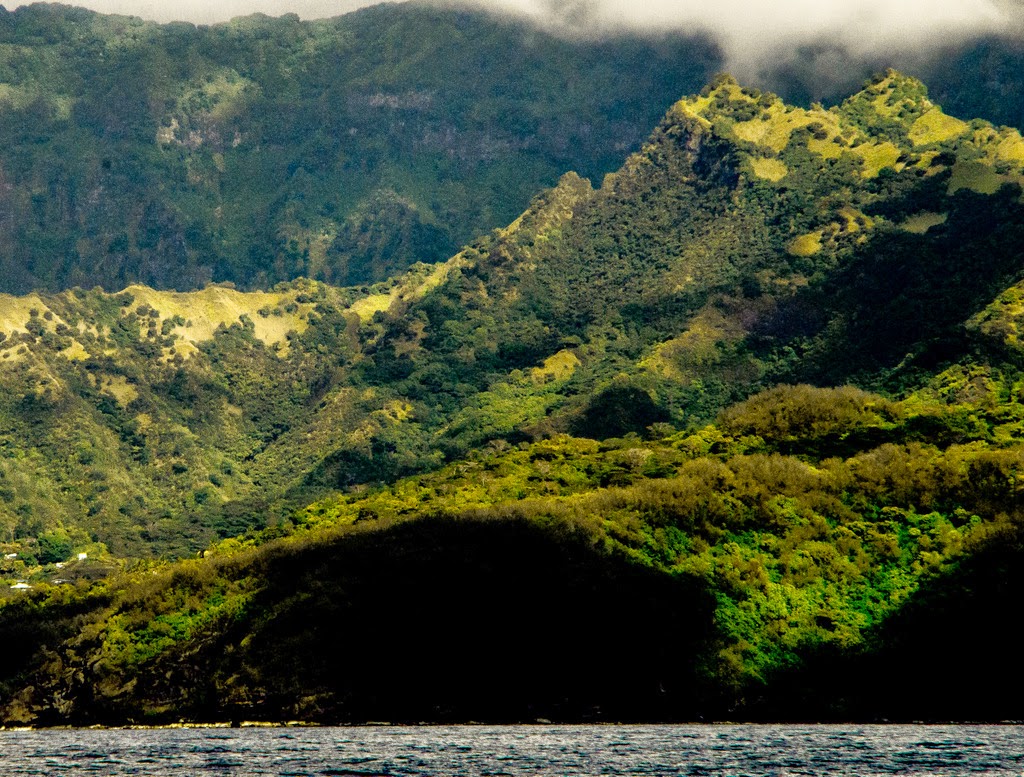
| South side of Hiva Oa, lit up at sunrise, on final approach. |
 |
| Hiva Oa approach after sunrise with rain showers ahead. |
 |
| A pensive Cat arrives after 40 days at sea. |
The Marquesas are
on the trailing edge of the eastern limits of the cyclone zone, which extends
from Australia, in the west, to half way across the expanse of the southern
Pacific Ocean, where we are currently located. It's rare to see a cyclone hit
here, in the Marquesas...famous last words, in the illogical world of ocean
weather.
Such a crazy, unbelievable journey! I really enjoyed reading this :) I still hope to see you guys one day somewhere!
ReplyDeleteMy first comment just disappeared, so forgive me if I'm somehow repeating. When I started catching up with you, then tracking Anna, I almost knew for a fact that you were headed for Polynesia, but not for certain until today. So happy to see that you're safe, and in such a place. This is such an exciting and exotic new chapter of your journey--I read this bog with intense fascination! The flying fish! The black whiskey! The photo of Cath when you finally arrived. The rainbow at your approach to Hiva Oa. The abundant fruit everywhere! I just can't wait to read your next blog entry. Lots of love, Frances
ReplyDelete